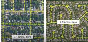
Houses Per Acre: Difference between revisions
Jump to navigation
Jump to search
(Created page with "File:housesperacre.jpg") |
No edit summary |
||
| (4 intermediate revisions by the same user not shown) | |||
| Line 1: | Line 1: | ||
[[File:housesperacre.jpg]] | [[File:housesperacre.jpg]] | ||
<html><iframe width="560" height="315" src="https://www.youtube.com/embed/_ysoAo08aHw" title="YouTube video player" frameborder="0" allow="accelerometer; autoplay; clipboard-write; encrypted-media; gyroscope; picture-in-picture" allowfullscreen></iframe></html> | |||
*After 1950s we started single use. Before it used to be integrated. | |||
*KC is 4x sprawled today than 1950 (area per house) | |||
*Points - use multiple use - multiple types of houses. Integrated use developments. | |||
*And - Tax land based on location, not improvement? What does that do? It would discourage parks, farms, etc, | |||
*East of Troost is ghetto by policy of redline | |||
Latest revision as of 20:06, 15 August 2021
- After 1950s we started single use. Before it used to be integrated.
- KC is 4x sprawled today than 1950 (area per house)
- Points - use multiple use - multiple types of houses. Integrated use developments.
- And - Tax land based on location, not improvement? What does that do? It would discourage parks, farms, etc,
- East of Troost is ghetto by policy of redline
