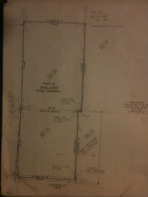
FeF Survey
Jump to navigation
Jump to search
Factor e Farm situated in the County of Dekalb, State of Missouri,and more particularly described as follows:
Commencing at the Southwest Corner of Section Three (3), Township Fifty-eight (58) North, Range Thirty-one (31) West, DeKalb County, Missouri; thence with the West line of the Southwest Quarter of said Section North 00°49'40” East, 1014.63 feet; thence departing from said line South 89°56'19” East, 705.82 feet to the East line of a tract of land recorded in Book 205 at Page 1204 in the office of the Recorder of Deeds, DeKalb County, Missouri; thence along the East line of said tract South 00°49'40” West, 1019.30 feet to the intersection of the East line of the said tract recorded in Book 205 at Page 1204 and the South line of.. the Southwest Quarter of Section Three (3); thence along the South line of the Southwest Quarter of Section Three (3), North 89°33'35” West, 35.76 feet to the Northwest Corner of a tract of land surveyed by Troy L. Hayes, PLS 2219, on April 7, 1994; thence along the West line of said tract surveyed by Troy L. Hayes, PLS 2219, South 00°49'57” West 802.21, feet to the Southwest Corner fo said tract surveyed by PLS 2219 on April 7, 1994, said point also being in the centerline of County Road 279; thence along the centerline of said. County Road 279 the following courses and distances; North 86°34'42” West, 118.39 feet; thence North 89°07'41” West, 550.02 feet to the West line of Section Ten (10); thence along said line North 00°42'36” East, 791.90 feet to the Point of Beginning.
Notes
- Township is 6x6 miles, going north and south. https://en.wikipedia.org/wiki/Public_Land_Survey_System
