Factor e Farm Site Plan: Difference between revisions
(→Links) |
|||
| (83 intermediate revisions by 7 users not shown) | |||
| Line 1: | Line 1: | ||
= | =2022 Improvements= | ||
=2021 Improvements= | |||
<html><iframe src="https://docs.google.com/presentation/d/1n5McoIjFtRKDxVyiny5wiJ7WBBJGNzyOLoWSfhbkxSE/embed?start=false&loop=false&delayms=3000#slide=id.gc59ef87690_0_197" frameborder="0" width="480" height=275" allowfullscreen="true" mozallowfullscreen="true" webkitallowfullscreen="true"></iframe></html> | |||
[https://docs.google.com/presentation/d/1n5McoIjFtRKDxVyiny5wiJ7WBBJGNzyOLoWSfhbkxSE/edit##slide=id.gc59ef87690_0_197 edit] | |||
==End of Year 2021== | |||
<html><iframe src="https://docs.google.com/presentation/d/1n5McoIjFtRKDxVyiny5wiJ7WBBJGNzyOLoWSfhbkxSE/embed?start=false&loop=false&delayms=3000#slide=id.gf740f4140e_0_0" frameborder="0" width="480" height=275" allowfullscreen="true" mozallowfullscreen="true" webkitallowfullscreen="true"></iframe></html> | |||
[https://docs.google.com/presentation/d/1n5McoIjFtRKDxVyiny5wiJ7WBBJGNzyOLoWSfhbkxSE/edit##slide=id.gc59ef87690_0_197 edit] | |||
==Cabins== | |||
<html><iframe src="https://docs.google.com/presentation/d/1n5McoIjFtRKDxVyiny5wiJ7WBBJGNzyOLoWSfhbkxSE/embed?start=false&loop=false&delayms=3000#slide=id.gc59ef87690_1_319" frameborder="0" width="480" height=275" allowfullscreen="true" mozallowfullscreen="true" webkitallowfullscreen="true"></iframe></html> | |||
[https://docs.google.com/presentation/d/1n5McoIjFtRKDxVyiny5wiJ7WBBJGNzyOLoWSfhbkxSE/edit##slide=id.gc59ef87690_1_319 edit] | |||
==Workshop== | |||
See [[Large Workshop Structure]] | |||
==Rural Electrification== | |||
Priority: connect Campsite to Power. PV on workship roof, with transfer switch. | |||
#Phase 1 - power to workshop | |||
#Phase 2 - power | |||
[[ | ==Internet== | ||
See [[OSE_Internet#Internet_Upgrades_2021]] | |||
[[ | =OSE Site Plan - from GIS Workshop of 2015= | ||
*[[GIS Workshop Site Plan 2015]]. | |||
*[[OSE_Site_Design_and_GIS_Workshop]] | |||
= | =Site Plan from Site Mapping and GIS Workshop, July 2015= | ||
*QGIS file -[[File:fef_siteplan_1.zip]] | |||
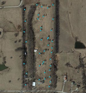
*'''Topsoil Cover''' - 40 points at FeF as baseline soil fertility data after decades of commercial abuse and no active regenerative effort- unzip, go to file manager, and open the .shp file. On Ubuntu 15.10 with QGIS 2.8, opening file from the Open File window did not work. - [[File:Soil samples interpolation.zip]] [[Image:soildepth.jpg|thumb|Soil data measurements taken in August 2015 during the [[Open Source Mapping and Site Design Workshop]]. More images: North Side - [[Image:soil2.jpg|70px]]. South Side - [[File:soil3.jpg|70px ]] ]]. | |||
*'''Note: topsoil cover above is largely qualitative. 5 teams took data walking north. Result depends on what the 5 teams thought was a layer above pure clay. The more accurate fertility measurement would come from the % carbon content. One test for this could be the biomass content of superficial soil (assuming highest % is at the top). This could be used as a better baseline over the years - as the same oint in the soil horizon can be tracked down the years.''' | |||
Download QGIS to view the above file. A screenshot with the layers: | |||
[[Image:Fefsiteplan.jpg|900px]] | |||
=Site Plan= | |||
<gallery perrow=6> | |||
File:site.jpeg|Factor e Farm (2012) | |||
File:sitemap.jpeg|Factor e Farm Site Plan [[File:siteplan.skp]] | |||
</gallery> | |||
=Agriculture Plan= | |||
See: [[Agriculture Plan 2013]] | |||
=Discussion= | =Discussion= | ||
*Marcin: | |||
Dan, | Dan, | ||
| Line 43: | Line 66: | ||
Marcin | Marcin | ||
*Dan | |||
I understand you have a need for some discussion around the following: | I understand you have a need for some discussion around the following: | ||
| Line 55: | Line 78: | ||
Please bring along your USGS quarter quad from the local NRCS office. You can also get the soils map of the place there too. I have Kuchler and Bailey resources for potential natural vegetation for that location. We'll look at your bio-region as well. | Please bring along your USGS quarter quad from the local NRCS office. You can also get the soils map of the place there too. I have Kuchler and Bailey resources for potential natural vegetation for that location. We'll look at your bio-region as well. | ||
=Permaculture Site Plan Logistics= | |||
[[Permaculture]] is a ecological design methodology based on a set of core principles and values that Open Source Ecology shares. Its primary application is to generate best practices for environmental site analysis and ecological site plan design but is also used to design ecological systems in general. | [[Permaculture]] is a ecological design methodology based on a set of core principles and values that Open Source Ecology shares. Its primary application is to generate best practices for environmental site analysis and ecological site plan design but is also used to design ecological systems in general. | ||
| Line 64: | Line 87: | ||
*idea 3: send a Factor E Farm member to a PDC course to get Permaculture certified and do the site plan | *idea 3: send a Factor E Farm member to a PDC course to get Permaculture certified and do the site plan | ||
==Permaculture Teachers== | |||
*Peter Bane | *Peter Bane | ||
*[http://www.midwestpermaculture.com/Instructors.php# Wayne Weiseman: Midwest Permaculture] | *[http://www.midwestpermaculture.com/Instructors.php# Wayne Weiseman: Midwest Permaculture] | ||
| Line 73: | Line 96: | ||
*Larry Santoyo | *Larry Santoyo | ||
=Online Resources= | |||
*FeF [[Integrated Development Strategy]] | |||
*'''[http://www.permaculture.info/index.php/Main_Page Permaculture Wiki]''' | *'''[http://www.permaculture.info/index.php/Main_Page Permaculture Wiki]''' | ||
*[http://www.pfaf.org/index.php Plants for a Future Database] >7k species, lots edible perennials | *[http://www.pfaf.org/index.php Plants for a Future Database] >7k species, lots edible perennials | ||
| Line 81: | Line 105: | ||
*[http://nzdl.sadl.uleth.ca/cgi-bin/library?e=d-00000-00---off-0fnl2.2--00-0--0-10-0--0-0---0prompt-10---4------4-0-1l--11-en-50-0--20-about--100-0-1-00-0-0-11-1-0utfZz-8-00-0-1-00-0-0-11-1-0utfZz-8-00&a=d&cl=CL1 Food and Nutrition Library 2.2] lots of free e-books on food, nutrition, farming | *[http://nzdl.sadl.uleth.ca/cgi-bin/library?e=d-00000-00---off-0fnl2.2--00-0--0-10-0--0-0---0prompt-10---4------4-0-1l--11-en-50-0--20-about--100-0-1-00-0-0-11-1-0utfZz-8-00-0-1-00-0-0-11-1-0utfZz-8-00&a=d&cl=CL1 Food and Nutrition Library 2.2] lots of free e-books on food, nutrition, farming | ||
= FeF Environmental Site Analysis = | |||
[[File:Soilmaponline2.jpg|thumb]] | |||
=Links= | |||
*Map on wikimapia - http://wikimapia.org/#lang=en&lat=39.863795&lon=-94.373540&z=17&m=b&show=/20957550/ | |||
*[[Agriculture_plan_2013]] - begun in winter, 2012, in progress. | |||
*[[FeF Master Plan]] - with [[John Motloch]] | |||
=Earthworks 2014= | |||
<html><iframe src="https://docs.google.com/presentation/d/1n5McoIjFtRKDxVyiny5wiJ7WBBJGNzyOLoWSfhbkxSE/embed?start=false&loop=false&delayms=3000" frameborder="0" width="480" height=275" allowfullscreen="true" mozallowfullscreen="true" webkitallowfullscreen="true"></iframe></html> | |||
[https://docs.google.com/presentation/d/1n5McoIjFtRKDxVyiny5wiJ7WBBJGNzyOLoWSfhbkxSE/edit#slide=id.g33ca76796_023 edit] | |||
[[Category: Food and Agriculture]] | [[Category: Food and Agriculture]] | ||
| Line 108: | Line 124: | ||
[[Category:FeF Master Plan]] | [[Category:FeF Master Plan]] | ||
[[Category:Gabi]] | [[Category:Gabi]] | ||
[[Category: Outdated Information]] | |||
=Links= | |||
*[[Infrastructure Improvements]] | |||
*[[OSE Infrastructure]] | |||
*[[Site Plan]] - how to do one | |||
*[[Registered Apprenticeship]] - considerations on infrastructure | |||
*'''[[Factor e Farm Utilities]]''' | |||
*[[Factor e Farm Improvements]] | |||
*[[OSE Internet]] - infrastructure map | |||
Latest revision as of 19:07, 12 June 2022
2022 Improvements
2021 Improvements
End of Year 2021
Cabins
Workshop
Rural Electrification
Priority: connect Campsite to Power. PV on workship roof, with transfer switch.
- Phase 1 - power to workshop
- Phase 2 - power
Internet
See OSE_Internet#Internet_Upgrades_2021
OSE Site Plan - from GIS Workshop of 2015
Site Plan from Site Mapping and GIS Workshop, July 2015
- QGIS file -File:Fef siteplan 1.zip
- Topsoil Cover - 40 points at FeF as baseline soil fertility data after decades of commercial abuse and no active regenerative effort- unzip, go to file manager, and open the .shp file. On Ubuntu 15.10 with QGIS 2.8, opening file from the Open File window did not work. - File:Soil samples interpolation.zip .
 Soil data measurements taken in August 2015 during the Open Source Mapping and Site Design Workshop. More images: North Side -
 . South Side -
- Note: topsoil cover above is largely qualitative. 5 teams took data walking north. Result depends on what the 5 teams thought was a layer above pure clay. The more accurate fertility measurement would come from the % carbon content. One test for this could be the biomass content of superficial soil (assuming highest % is at the top). This could be used as a better baseline over the years - as the same oint in the soil horizon can be tracked down the years.


Download QGIS to view the above file. A screenshot with the layers:

Site Plan
Factor e Farm (2012)
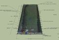
Factor e Farm Site Plan File:Siteplan.skp


Agriculture Plan
Discussion
- Marcin:
Dan,
I just called - the soils map people referred me to http://websoilsurvey.nrcs.usda.gov/app/WebSoilSurvey.aspx
I spoke to Jason Saunders. He said the above has 2009 or 2010 aerial photography. He said the USGS quarter quad shows images from about 2001, so he recommended just the online stuff.
Their number in the DeKalb County NRCS office is 816.449.2118.
Let me know what we still need.
I looked at the soils: here is the result: the border is our 30 acres:
http://opensourceecology.org/wiki/Factor_e_Farm_Site_Plan
Marcin
- Dan
I understand you have a need for some discussion around the following:
- Small scale methane
- Single family and community sized constructed wetlands for domestic waste treatment and disposal
- Aquaculture/aquaponics
- water filtration and purification
- Small (1 acre) cattle and pasture development
- Land drainage and soil regeneration
Please bring along your USGS quarter quad from the local NRCS office. You can also get the soils map of the place there too. I have Kuchler and Bailey resources for potential natural vegetation for that location. We'll look at your bio-region as well.
Permaculture Site Plan Logistics
Permaculture is a ecological design methodology based on a set of core principles and values that Open Source Ecology shares. Its primary application is to generate best practices for environmental site analysis and ecological site plan design but is also used to design ecological systems in general.
- idea 1: host a permaculture course at the Factor e Farm and have the course practicum be a site plan for Factor e Farm
- idea 2: host an individual permaculture designer in exchange for food, board and fame
- User:Liam.rattray volunteers to do conduct an on-site environmental analysis and provide a comprehensive site plan for FeF over a week from 3/20/10 to 3/28/10 in exchange for cooperation in constructing a modified CEB press.
- idea 3: send a Factor E Farm member to a PDC course to get Permaculture certified and do the site plan
Permaculture Teachers
- Peter Bane
- Wayne Weiseman: Midwest Permaculture
- Chuck Marsh
- Patricia Allen
- Bob Burns * Isabel Crabtree
- Penny Livingston
- Larry Santoyo
Online Resources
- FeF Integrated Development Strategy
- Permaculture Wiki
- Plants for a Future Database >7k species, lots edible perennials
- NewCrop Perdue's edible species profiles
- AgroForestryTree Database World Agroforestry Center's tree species profiles
- Forest, Farm, and Community Tree Network more agroforestry resources
- Food and Nutrition Library 2.2 lots of free e-books on food, nutrition, farming
FeF Environmental Site Analysis

Links
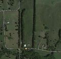
- Map on wikimapia - http://wikimapia.org/#lang=en&lat=39.863795&lon=-94.373540&z=17&m=b&show=/20957550/
- Agriculture_plan_2013 - begun in winter, 2012, in progress.
- FeF Master Plan - with John Motloch
Earthworks 2014
Links
- Infrastructure Improvements
- OSE Infrastructure
- Site Plan - how to do one
- Registered Apprenticeship - considerations on infrastructure
- Factor e Farm Utilities
- Factor e Farm Improvements
- OSE Internet - infrastructure map